A GEO Data file is used for importing data about individual parts within 3DCS. A "GEO" file contains parametric information about a node in an assembly.
Procedure:
•Branch on the part that you want to export the geo file for.
•Select File / Export
•Select GEO Data from the Save as Type drop-down.
•Modify the file name or leave the default.
•Press Save
The points to be imported into 3DCS should be in a text file with a GEO extension. If the points are created in Excel, save as a TXT format file with a GEO extension. The name of the file should be the same as the part name in the model.
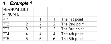
If you are importing points without vectors, the geo file should look like example 1 (first line is VERNUM 3001).
The key words in the first two rows in column one must be in capital letters.
The number after PTNUM refers to the number of points in the list to import.
The information in rows 3 through n is as follows:
•Column 1: The point name.
•Column 2: The X coordinate.
•Column 3: The Y coordinate.
•Column 4: The Z coordinate.
•Column 5: Point description. This column is optional.

If you want to import coordinates and vectors, use example 2 (first line is VERNUM 3002).
The key words in the first two rows in column one must be in capital letters.
The number after PTNUM refers to the number of points in the list to import.
The information in rows 3 through n is the following:
•Column 1: The point name.
•Column 2: The X coordinate.
•Column 3: The Y coordinate.
•Column 4: The Z coordinate.
•Column 5: The i vector component.
•Column 6: The j vector component.
•Column 7: The k vector component.
•Column 8: Point description. This column is optional.

After the GEO file has been saved, select File\Import in 3DCS. Make sure File Type is GEO data (*.geo). Go to the drive and directory containing the GEO file, select the file and pick open. If there is not a part with the name of the geo file, a new part will be added to the tree. If the part exists, a dialog box will appear asking if you want the part replaced. If you select No, a new part will be added with the points. If you select Yes, the points will be added to the part if they don't already exist, or the coordinates and i, j and k will be replaced if the points do exist.